Ever wonder what the types of fronts you see on the weather map mean? As part of our continuing weather education series, we thought an explainer would be helpful. So let’s get started.
The polar and subtropical jets separate air masses. This boundary is known as a front. If it sounds a bit militaristic, it is because meteorologists gave these boundaries this name for the similarity to a military unit moving across the battlefield.
Although not a hard and fast rule, most of these fronts will ride along ripples on the polar and subtropical jets, changing the weather as they pass. Four types of fronts exist: cold, warm, occluded, and stationary.
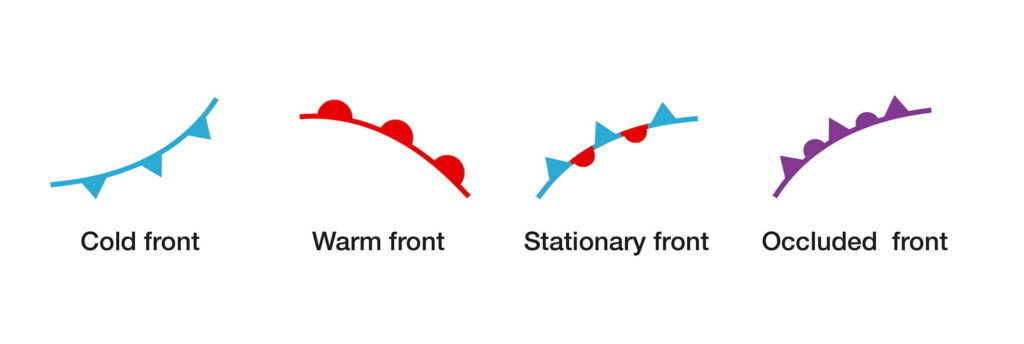
The Three Main Types of Fronts
Some cold fronts may tear through violently with high winds and storms with noticeably cooler air masses behind them. In contrast, others will pass with barely any noticeable difference except a change in humidity and more pleasant weather.
Warm fronts are typically much less benign. Severe storms with tornadic activity can occur near warm fronts, thanks to increased amounts of spin. Occluded fronts are mixtures, any combination of weather, temperature, and/or humidity change. Their effects are widely variable.
Stationary fronts, when a boundary stays in place, sit over the same area for days at a time and frequently are the cause of excessive rainfall in the summer months and “stagnant” weather patterns.
Cold fronts on a weather map are typically depicted as a blue line with triangles on it, the triangles indicating the direction of movement. Warm fronts are red lines with half-circles, those half-circles pointing in the direction of movement, while occluded fronts are shown in purple with alternating triangles and half-circles.
Cold Fronts
The cold front is typically the most active. There is a noticeable wind shift and increase in wind speed as it passes, and both the temperature and humidity drop – sometimes quite significantly. It typically moves west to east over the US, replacing warmer, more humid air masses. Because colder air is denser than warmer air, a cold front ‘scours’ warm air out, as shown below in the diagram.
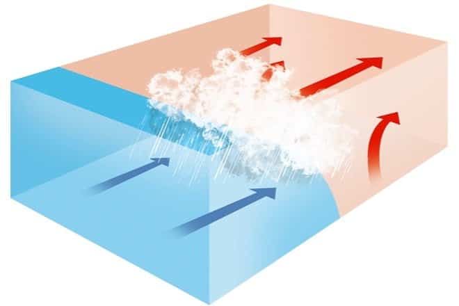
What weather does a cold front bring?
| Before Passing | While Passing | After Passing | |
|---|---|---|---|
| Winds | south-southwest | gusty; shifting | west-northwest |
| Temperature | warm | sudden drop | steadily dropping |
| Pressure | falling steadily | minimum, then a sharp rise | rising steadily |
| Clouds | increasing: Ci, Cs and Cb | Cb | Cu |
| Precipitation | short period of showers | heavy rains, sometimes with hail, thunder, and lightning | showers then clearing |
| Visibility | fair to poor in haze | poor, followed by improving | good, except in showers |
| Dew Point | high; remains steady | sharp drop | lowering |
Note: Ci = cirrus, Cs = cirrostratus, Cb = cumulonimbus, Cu = cumulus, As = altostratus, Ns = nimbostratus, St = stratus, Sc = stratocumulus, Tcu = towering cumulus
Warm Fronts
Warm fronts do the opposite of cold fronts, so warmer air replaces colder air. Warmer air is less dense, so it will move over the top of colder air as it travels (the opposite of a cold front — see diagram). Warm fronts typically move from south to north in the Northern Hemisphere, with increased air temperature and humidity behind them. In some cases, severe weather may break out just behind a warm front due to increased instability.
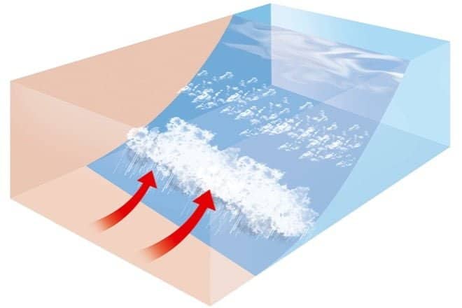
What weather does a warm front bring?
| Before Passing | While Passing | After Passing | |
|---|---|---|---|
| Winds | south-southeast | variable | south-southwest |
| Temperature | cool-cold, slow warming | steady rise | warmer, then steady |
| Pressure | usually falling | leveling off | slight rise, followed by fall |
| Clouds | in this order: Ci, Cs, As, Ns, St, and fog; occasionally Cb in summer | stratus-type | clearing with scattered Sc; occasionally Cb in summer |
| Precipitation | light-to-moderate rain, snow, sleet, or drizzle | drizzle or none | usually none, sometimes light rain or showers |
| Visibility | poor | poor, but improving | fair in haze |
| Dew Point | steady rise | steady | rise, then steady |
Note: Ci = cirrus, Cs = cirrostratus, Cb = cumulonimbus, Cu = cumulus, As = altostratus, Ns = nimbostratus, St = stratus, Sc = stratocumulus, Tcu = towering cumulus
Occluded Fronts
Occlusion is where a cold front catches up to a warm front. As a result, the air out ahead of an occlusion will be different in some way from the air behind it. Generally speaking, in a warm occlusion, the air behind an occluded front is even warmer than the air ahead of a warm front. In a cold occlusion, the most common, the air behind the occlusion is colder than the air out ahead of the warm front (not colder than the air ahead of a cold front). See the chart below.
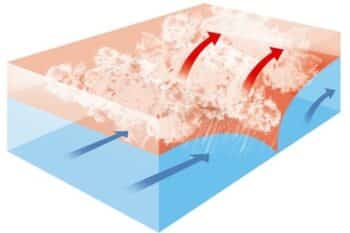
What weather does an occluded front bring?
| Before Passing | While Passing | After Passing | |
|---|---|---|---|
| Winds | southeast-south | variable | west to northwest |
| Temperature Cold Type Warm Type | cold-cool cold | dropping rising | colder milder |
| Pressure | usually falling | low point | usually rising |
| Clouds | in order: Ci, Cs, As, Ns | Ns, sometimes Tcu and Cb | Ns, As or scattered Cu |
| Precipitation | light, moderate or heavy precipitation | light, moderate or heavy continuous precipitation or showers | light-to-moderate precipitation followed by general clearing |
| Visibility | poor in precipitation | poor in precipitation | improving |
| Dew Point | steady | usually a slight drop, especially if cold-occluded | slight drop, although may rise a bit if warm-occluded |
Note: Ci = cirrus, Cs = cirrostratus, Cb = cumulonimbus, Cu = cumulus, As = altostratus, Ns = nimbostratus, St = stratus, Sc = stratocumulus, Tcu = towering cumulus
Stationary Fronts
As the name implies, a stationary front is a cold or warm front that is no longer moving. The blue triangles of the cold front point toward the warmer air, and the red half-circles of the warm front towards the cold. One of its most noticeable features is a marked temperature and wind direction difference on each side. A stationary front can also be a focal point for atmospheric lift and convergence, creating clouds and precipitation. These fronts are a common cause of excessive precipitation year-round.
Drylines
Most areas of the country don’t experience these often, but since this is a book on American weather it’s important to mention the dryline. These fronts are most commonly found in the Plains during the summer. You can think of these drylines as a difference in humidity: warm, humid air on one side and dry, hot air on the other. This is typically shown as a dashed yellow or orange line on a weather map. In the summer months, drylines trigger thunderstorms, often severe.
Want to learn more?
This post is an excerpt from my book, Weather Watch: An Introduction to America’s Weather and Climate, available on Amazon, and free for Kindle Unlimited subscribers!
Experience the fascinating world of weather with the second edition of Weather Watch: An Introduction to America’s Weather and Climate. This book doesn’t just explain weather and climate concepts—it brings them to life.
Weather Watch is perfect for teenagers and adults who wish to deepen their understanding of the dynamic world of meteorology. Simplifying the complex, this book breaks down the science of weather into smaller, easily digestible concepts, allowing you to build on your knowledge with each chapter.
Here’s what to expect:
- Detailed insights on clouds, pressure and wind, reading weather maps, hurricanes, and tropical storms
- Enlightening discussion on climate change
- Essential guidance on purchasing a weather station
- Critical information on severe weather and tornadoes
- Learning how to forecast the weather yourself
This second edition comes completely reformatted with over 30 pages of new content, including advanced weather map analysis and space weather. It’s more visually appealing with additional illustrations and graphics. Each chapter now ends with handy links for more in-depth learning, and sprinkled throughout the book are captivating American weather events, serving as real-life illustrations of introduced concepts.

