

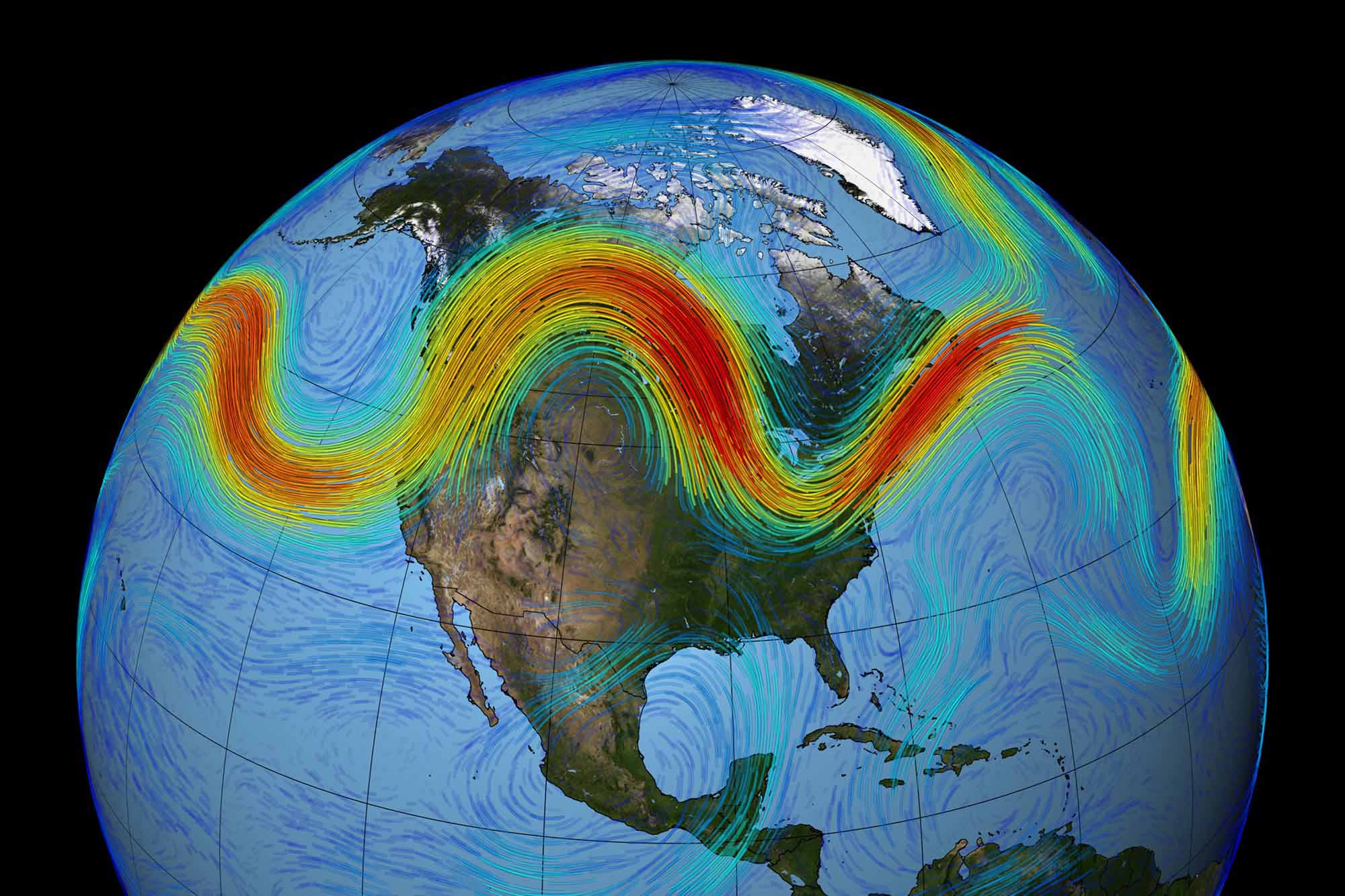
The jet stream is a narrow band of strong winds in the upper levels of Earth’s atmosphere, and it blows from west to east and provides a corridor for storms to follow as they circumnavigate the globe. Jet streams form along the boundaries of warm and cold air, and the wiggles of the jet stream play a large part in the weather you experience.
Generally, jet streams are strongest during the winter months since the temperature differences between the warm and cold air masses are most significant at this time.
Winds in the upper levels of the atmosphere along the jet stream can be as fast as 200mph and sometimes higher, providing the impetus to push weather systems along and ahead of it. Jet stream winds are found about 30,000 feet in the air, the same height airplanes fly. Pilots use the jet stream to conserve fuel on west to east trips, although passing through especially strong portions of the jet stream, called jet streaks, perpendicularly can cause heavy turbulence.
If you’ve ever wondered why a plane trip from east to west takes longer than the return trip, this is why. On the trip west, the plane must contend with winds blowing towards the aircraft, slowing it down. However, coming east, the winds blow against the plane’s rear, which allows the airplane to fly much faster on the return trip.
This also explains why a pilot may not fly a perfectly straight route west to east. IThepilot will pass through a weaker portion of the jet stream to decrease turbulence. if possible
How the Jet Stream Affects Our Weather
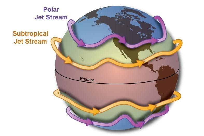
There are two main jet streams in our atmosphere, the polar and subtropical jet. The subtropical jet retreats to the tropics in winter and moves northward into the mid-latitudes during the summer. On the other hand, the polar jet remains closer to the poles for much of the year but becomes stronger in the winter months and dives southward into the northern mid-latitudes during the winter, occasionally dipping into the sub-tropics during especially severe cold spells.
A southerly dip in the polar jet stream can also help displace the polar vortex from its usual position above 60 degrees of latitude (this isn’t the only reason why it behaves as it does, which we discuss here).
When the jet stream develops a northerly hump over land, known as a ridge, those within the ridge see dry and warmer weather. Conversely, a southerly dip, known as a trough, signals cooler and drier weather, although close to the jet stream, storms and precipitation may form. Fronts form along and move with the jet stream, and low-pressure systems typically track along or close to its path.
Low-Level Jet Streams
While the polar and subtropical jet is responsible for our varied weather, other types of jet streams can form from time to time closer to the surface. These are often referred to as “low-level jets.”
During the summer, thunderstorms often develop on the downdraft of cold fronts. This downdraft creates a microscale jet stream that funnels air towards the ground, where it can help to initiate thunderstorms.
Another type of low-level jet is called an elevated mixed layer. During this event, winds at the surface are relatively calm, but a jet stream develops at a high altitude and blows down to the surface. Elevated mixed layers typically form over mountain ranges as air descends on the other side of the mountains, creating an elevated region of low pressure which helps to draw winds from aloft to the ground.
The infamous Santa Ana Winds are also the byproduct of a low-level jet. During the day, Santa Ana Winds create a low-level jet stream along the California coast and southern Nevada, which helps heat and dry out the air before approaching storms.
At night, this jet stream collapses, and winds blow from the interior toward the coast, sometimes reaching hurricane force. If they occur during wildfire season, they can turn a small brush fire into a several thousand-acre conflagrations in a matter of hours.
Great Lakes winter cyclones are another example of a low-level jet stream. The low-pressure system formed over the Great Lakes, coupled with cold winds from Canada and the north, push a horizontal jet stream southward into nearby states. During these events, strong winds occur near Lake Michigan, and Lake Huron as warmer air becomes trapped over the colder water of the lakes.
Jet Streams Aren’t Just an Earthly Concept
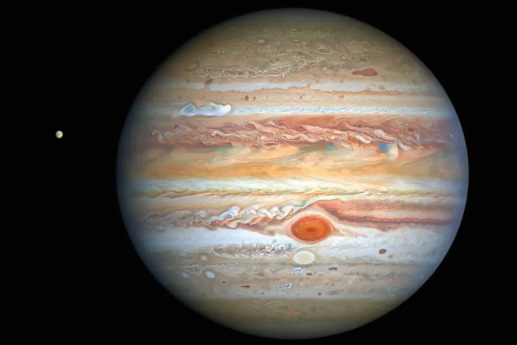
While jet streams are most commonly associated with Earth’s atmosphere, they are found on other planets. Astronomers have observed multiple jet streams on Jupiter’s surface, which are visible thanks to the colorful clouds of the planet’s atmosphere.
Other planets have jet streams, too: Saturn is home to a “sub-tropical ridge,” and Uranus has an “atmospheric collar” of winds that circle its north and south poles. While we haven’t been able to directly observe the atmospheres of the thousands of planets discovered over the past several decades, many of these exoplanets likely have similar atmospheric phenomena to the jet streams we see here on Earth.