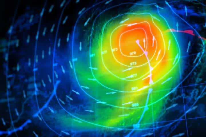
Vi siete mai chiesti cosa significhino i tipi di fronti che vedete sulla carta meteorologica? Come parte della nostra continua educazione meteorologica serie, abbiamo pensato che una spiegazione sarebbe stata utile. Quindi iniziamo.
I getti polari e subtropicali separano le masse d'aria. Questo confine è noto come fronte. Se suona un po' militaresco, è perché i meteorologi hanno dato a questi confini questo nome per la somiglianza con un'unità militare che si muove sul campo di battaglia.
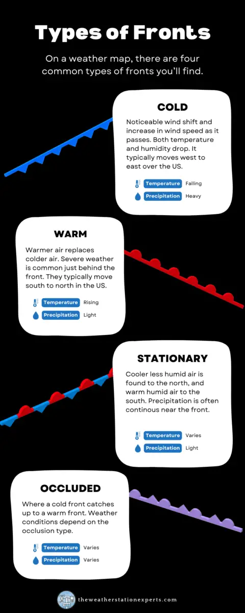
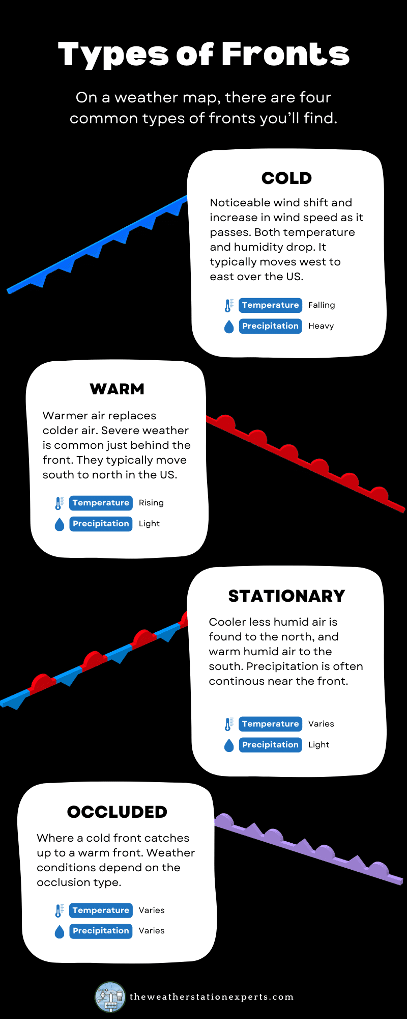
Anche se non si tratta di una regola ferrea, la maggior parte di questi fronti viaggia lungo le increspature delle gettate polari e subtropicali, cambiando il tempo al loro passaggio. Esistono quattro tipi di fronti: freddo, caldo, occluso e stazionario.
Infografica
Abbiamo sintetizzato le istruzioni riportate di seguito in un'infografica di facile comprensione per i nostri abbonati. Per motivi di prestazioni, in questa pagina viene mostrata un'immagine di qualità inferiore. Per salvare l'immagine a dimensione intera sul tuo computer, fai clic sul pulsante "download" sotto l'infografica.
I tre principali tipi di fronti
Alcuni fronti freddi possono squarciarsi violentemente venti forti e temporali con masse d'aria notevolmente più fresche alle spalle. Al contrario, altri passeranno con differenze appena percettibili, tranne un cambiamento di umidità e un clima più piacevole.
I fronti caldi sono in genere molto meno benigni. Forti tempeste con attività tornadica possono verificarsi vicino a fronti caldi, grazie alla maggiore quantità di rotazione. I fronti occlusi sono miscele, qualsiasi combinazione di cambiamenti meteorologici, di temperatura e/o di umidità. I loro effetti sono ampiamente variabili.
I fronti stazionari, quando un confine rimane al suo posto, siedono sulla stessa area per giorni consecutivi e spesso sono la causa di precipitazioni eccessive nei mesi estivi e di modelli meteorologici “stagnanti”.
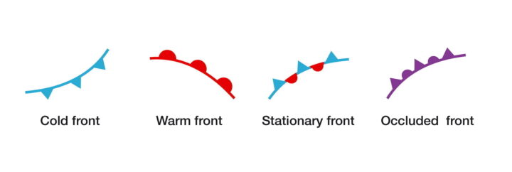
I fronti freddi su una mappa meteorologica sono tipicamente rappresentati come una linea blu con dei triangoli che indicano la direzione del movimento. I fronti caldi sono linee rosse con semicerchi che indicano la direzione del movimento, mentre i fronti occlusi sono rappresentati in viola con triangoli e semicerchi alternati.
Fronti freddi
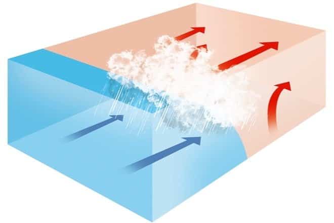
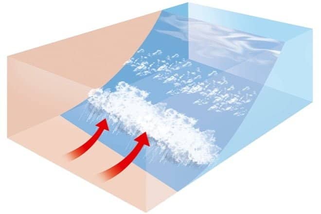
Il fronte freddo è in genere il più attivo. Al suo passaggio si verifica un notevole spostamento e aumento della velocità del vento, e sia la temperatura che l'umidità diminuiscono, a volte in modo significativo. In genere si sposta da ovest a est sugli Stati Uniti, sostituendo l'aria più calda e umida. Poiché l'aria più fredda è più densa di quella più calda, un fronte freddo "spazza via" l'aria calda, come mostrato nel diagramma sottostante.
Che tempo porta un fronte freddo?
| Prima del trapasso | Durante il passaggio | Dopo il trapasso | |
|---|---|---|---|
| Venti | sud-sud-ovest | rafficato; mutevole | ovest-nord-ovest |
| Temperatura | caldo | calo improvviso | in costante calo |
| Pressione | in costante calo | minimo, poi un forte aumento | in costante aumento |
| Nuvole | in aumento: Ci, Cs e Cb | Cb | Cu |
| Precipitazioni | breve periodo di docce | piogge intense, a volte con grandine, tuono e fulmine | rovesci e poi schiarite |
| Visibilità | da discreto a scarso nella foschia | poveri, seguiti dal miglioramento | buono, tranne che nelle docce |
| Punto di rugiada | alto; rimane stabile | forte calo | abbassamento |
Nota: Ci = cirri, Cs = cirrostrati, Cb = cumulonembi, Cu = cumuli, As = altostrati, Ns = nimbostrati, St = stratus, Sc = stratocumuli, Tcu = cumuli torreggianti.
Fronti caldi
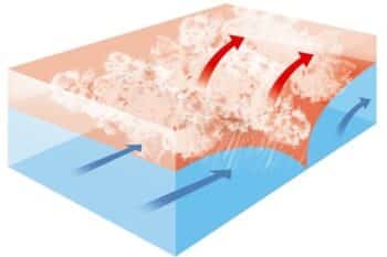
I fronti caldi fanno l'opposto dei fronti freddi, quindi l'aria più calda sostituisce quella più fredda. L'aria più calda è meno densa, quindi si sposta sopra l'aria più fredda mentre viaggia (l'opposto di un fronte freddo - vedi diagramma). I fronti caldi si spostano tipicamente da sud a nord nell'emisfero settentrionale, con un aumento della temperatura e dell'umidità dell'aria dietro di loro. In alcuni casi, il maltempo può scoppiare proprio dietro un fronte caldo, a causa di una maggiore instabilità.
Che tempo porta un fronte caldo?
| Prima del trapasso | Durante il passaggio | Dopo il trapasso | |
|---|---|---|---|
| Venti | sud-sud-est | variabile | sud-sud-ovest |
| Temperatura | freddo-freddo, riscaldamento lento | aumento costante | più caldo, poi costante |
| Pressione | di solito in calo | livellamento | leggero aumento, seguito da una diminuzione |
| Nuvole | nell'ordine: Ci, Cs, As, Ns, St e fog; occasionalmente Cb in estate. | tipo stratus | schiarite con sparse Sc; occasionalmente Cb in estate |
| Precipitazioni | pioggia da leggera a moderata, neve, nevischio, o a pioggia | pioggerella o niente | di solito nessuna, a volte pioggia o rovesci leggeri |
| Visibilità | povero | povero, ma in miglioramento | fiera nella foschia |
| Punto di rugiada | aumento costante | costante | aumento, poi costante |
Nota: Ci = cirri, Cs = cirrostrati, Cb = cumulonembi, Cu = cumuli, As = altostrati, Ns = nimbostrati, St = stratus, Sc = stratocumuli, Tcu = cumuli torreggianti.
Fronti occlusi
Per definizione, un'occlusione è il punto in cui il fronte freddo raggiunge il fronte caldo. Di conseguenza, l'aria che precede un'occlusione sarà in qualche modo diversa da quella che si trova dietro di essa. In generale, in un'occlusione calda, l'aria dietro un fronte occluso è ancora più calda dell'aria davanti al fronte caldo. In un'occlusione fredda, la più comune, l'aria dietro l'occlusione è più fredda dell'aria fuori davanti al fronte caldo (non più fredda dell'aria davanti a un fronte caldo). freddo anteriore). Vedere la tabella seguente.
Che tempo fa un fronte occluso?
| Prima del trapasso | Durante il passaggio | Dopo il trapasso | |
|---|---|---|---|
| Venti | sud-est-sud | variabile | da ovest a nord-ovest |
| Temperatura Tipo freddo Tipo caldo | freddo-freddo freddo | caduta in aumento | più freddo più mite |
| Pressione | di solito in calo | punto basso | solitamente in aumento |
| Nuvole | in ordine: Ci, Cs, As, Ns | Ns, a volte Tcu e Cb | Ns, As o Cu sparso |
| Precipitazioni | precipitazioni leggere, moderate o intense | precipitazioni o rovesci continui di lieve, moderata o forte intensità | precipitazioni da leggere a moderate seguite da schiarite generali |
| Visibilità | povero di precipitazioni | povero di precipitazioni | migliorare |
| Punto di rugiada | costante | di solito una leggera flessione, soprattutto se si tratta di un'intercettazione a freddo | leggero calo, anche se può aumentare un po' se si è avvolti dal caldo |
Nota: Ci = cirri, Cs = cirrostrati, Cb = cumulonembi, Cu = cumuli, As = altostrati, Ns = nimbostrati, St = stratus, Sc = stratocumuli, Tcu = cumuli torreggianti.
Fronti fissi
Come suggerisce il nome, un fronte stazionario è un fronte freddo o caldo che non si muove più. I triangoli blu del fronte freddo puntano verso l'aria più calda, mentre i semicerchi rossi del fronte caldo puntano verso l'aria fredda. Una delle sue caratteristiche più evidenti è la marcata differenza di temperatura e direzione del vento su ciascun lato. Un fronte stazionario può anche essere un punto focale per la risalita atmosferica e la convergenza, creando nuvole e le precipitazioni. Questi fronti sono una causa comune di precipitazioni eccessive durante tutto l'anno.
Linee a secco
Nella maggior parte delle aree del Paese non si verificano spesso, ma poiché questo è un libro sul clima americano, è importante menzionare le dryline. Questi fronti sono più comuni nelle pianure durante l'estate. Si può pensare a queste dryline come a una differenza di umidità: aria calda e umida da un lato e aria secca e calda dall'altro. In genere sono rappresentate da una linea gialla o arancione tratteggiata su una carta meteorologica. Nei mesi estivi, le dryline sono un fattore scatenante dei temporali, spesso di forte intensità. temporalispesso gravi.
Volete saperne di più?
Questo post è un estratto del mio libro, Weather Watch: Un'introduzione al tempo e al clima dell'Americadisponibile su Amazon e gratuito per gli abbonati a Kindle Unlimited!

Vivi l'affascinante mondo del tempo con la seconda edizione di Weather Watch: un'introduzione all'America Tempo e clima. Questo libro non si limita a spiegare i concetti relativi al tempo e al clima, ma li porta in vita.
Vigilanza meteorologica è perfetto per adolescenti e adulti che desiderano approfondire la comprensione del dinamico mondo della meteorologia. Semplificando il complesso, questo libro scompone la scienza del tempo in concetti più piccoli e facilmente digeribili, permettendoti di ampliare le tue conoscenze in ogni capitolo.
Ecco cosa aspettarsi:
- Approfondimenti dettagliati su nuvole, pressione e vento, lettura di mappe meteorologiche, uragani e tempeste tropicali
- Discussione illuminante sul cambiamento climatico
- Guida essenziale all'acquisto di una stazione meteorologica
- Informazioni critiche su condizioni meteorologiche avverse e tornado
- Imparare a prevedere il tempo da soli
Questa seconda edizione viene completamente riformattata con oltre 30 pagine di nuovi contenuti, tra cui analisi avanzate delle mappe meteorologiche e meteorologia spaziale. È visivamente più accattivante con illustrazioni e grafica aggiuntive. Ogni capitolo ora termina con collegamenti utili per un apprendimento più approfondito e, sparsi in tutto il libro, sono accattivanti eventi meteorologici americani, che servono come illustrazioni di vita reale dei concetti introdotti.

