Har du någonsin undrat vad de olika typerna av fronter som du ser på väderkartan betyder? Som en del av vår fortlöpande utbildning i väder serie, vi trodde att en förklarare skulle vara till hjälp. Så låt oss börja.
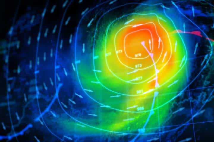
De polära och subtropiska jetstrålarna separerar luftmassorna. Denna gräns är känd som en front. Om det låter lite militaristiskt beror det på att meteorologerna gav dessa gränser detta namn på grund av likheten med en militär enhet som rör sig över slagfältet.
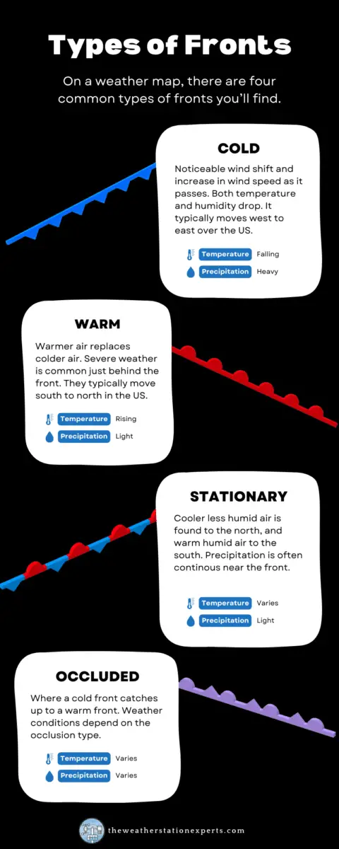
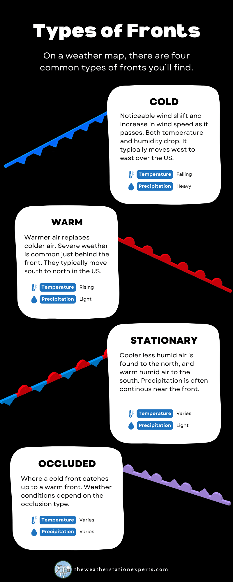
Även om det inte är en fast regel så följer de flesta av dessa fronter krusningarna på de polära och subtropiska jetstrålarna och förändrar vädret när de passerar. Det finns fyra typer av fronter: kalla, varma, ockluderade och stationära.
Infografik
Vi har destillerat informationen nedan till en lättförståelig infografik för våra prenumeranter. Av prestandaskäl visas en bild av lägre kvalitet på den här sidan. För att spara bilden i full storlek på din dator, klicka på knappen "ladda ner" under infografiken.
De tre huvudtyperna av fronter
Vissa kallfronter kan slita igenom våldsamt med kraftiga vindar och stormar med märkbart svalare luftmassor bakom sig. Däremot kommer andra att passera med knappt någon märkbar skillnad förutom en förändring i luftfuktighet och behagligare väder.
Varmfronter är vanligtvis mycket mindre godartade. Kraftiga stormar med tornadisk aktivitet kan uppstå nära varma fronter, tack vare ökade mängder spinn. Tilltäppta fronter är blandningar, alla kombinationer av väder-, temperatur- och/eller fuktighetsförändringar. Deras effekter är mycket varierande.
Stationära fronter, när en gräns förblir på plats, sitter över samma område i dagar i taget och är ofta orsaken till överdriven nederbörd under sommarmånaderna och "stagnerande" vädermönster.
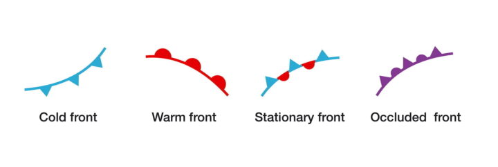
Kallfronter på en väderkarta visas vanligtvis som en blå linje med trianglar på, där trianglarna anger rörelseriktningen. Varmfronter är röda linjer med halvcirklar, där halvcirklarna pekar i rörelseriktningen, medan ockluderade fronter visas i lila med omväxlande trianglar och halvcirklar.
Kallfronter
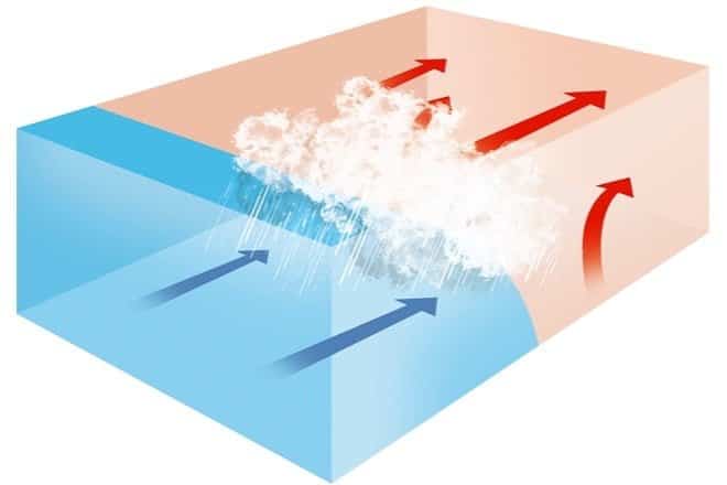
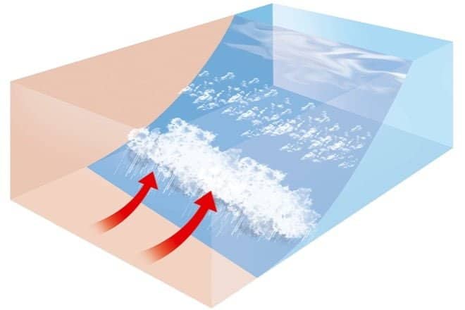
Kallfronten är vanligtvis den mest aktiva. Det finns en märkbar vindförskjutning och ökad vindhastighet när den passerar, och både temperatur och luftfuktighet sjunker – ibland ganska rejält. Det rör sig vanligtvis från väst till öst över USA och ersätter varmare, fuktigare luftmassor. Eftersom kallare luft är tätare än varmare, "skurar" en kallfront ut varm luft, som visas nedan i diagrammet.
Vilket väder medför en kallfront?
| Före passering | Under passage | Efter godkänt | |
|---|---|---|---|
| Vindar | syd-sydväst | byig; skiftande | väst-nordväst |
| Temperatur | varm | plötslig minskning | stadigt sjunkande |
| Tryck | faller stadigt | minimum, sedan en kraftig ökning | stiger stadigt |
| Moln | ökande: Ci, Cs och Cb | Cb | Cu |
| Nederbörd | kort period av skurar | kraftiga regn, ibland med hagel, åska och blixt | skurar sedan uppklarnande |
| Synlighet | måttlig till dålig i dis | dålig, följt av förbättring | bra, förutom i duschar |
| Daggpunkt | hög; förblir stabil | kraftigt fall | sänkning |
Anmärkning: Ci = cirrus, Cs = cirrostratus, Cb = cumulonimbus, Cu = cumulus, As = altostratus, Ns = nimbostratus, St = stratus, Sc = stratocumulus, Tcu = towering cumulus
Varmfront
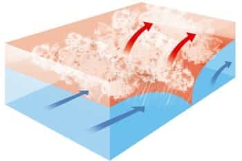
Varmfronter gör motsatsen till kallfronter, så varmare luft ersätter kallare luft. Varmare luft är mindre tät, så den kommer att röra sig ovanpå kallare luft när den rör sig (motsatsen till en kallfront - se diagram). Varmfronter rör sig vanligtvis från söder till norr på norra halvklotet, med ökad lufttemperatur och luftfuktighet bakom sig. I vissa fall kan hårt väder bryta ut precis bakom en varmfront på grund av ökad instabilitet.
Vilket väder medför en varmfront?
| Före passering | Under passage | Efter godkänt | |
|---|---|---|---|
| Vindar | syd-sydost | variabel | syd-sydväst |
| Temperatur | kall-kall, långsam uppvärmning | stadig ökning | varmare, sedan stadig |
| Tryck | faller vanligtvis | utjämning | svag uppgång, följt av nedgång |
| Moln | i denna ordning: Ci, Cs, As, Ns, St och fog; ibland Cb på sommaren | Stratus-typ | kalhygge med spridda Sc; ibland Cb på sommaren |
| Nederbörd | Lätt till måttligt regn, snö, sleet, eller ringla över | droppa eller ingen | vanligtvis ingen, ibland lätt regn eller skurar |
| Synlighet | fattig | dålig, men förbättras | ljus i dis |
| Daggpunkt | stadig ökning | stadig | stiger, sedan stadigt |
Anmärkning: Ci = cirrus, Cs = cirrostratus, Cb = cumulonimbus, Cu = cumulus, As = altostratus, Ns = nimbostratus, St = stratus, Sc = stratocumulus, Tcu = towering cumulus
Okluderade fronter
Ocklusion är när en kallfront kommer ikapp en varmfront. Som ett resultat av detta kommer luften framför en ocklusion att skilja sig på något sätt från luften bakom den. Generellt sett är luften bakom en ockluderad front ännu varmare än luften framför en varm front vid en varm ocklusion. I en kall ocklusion, som är den vanligaste, är luften bakom ocklusionen kallare än luften framför den varma fronten (inte kallare än luften framför en kyla front). Se tabellen nedan.
Vilket väder ger en ockluderad front?
| Före passering | Under passage | Efter godkänt | |
|---|---|---|---|
| Vindar | sydost-syd | variabel | väst till nordväst |
| Temperatur Kall typ Varm typ | kall-kyl kyla | droppande stigande | kallare mildare |
| Tryck | faller vanligtvis | låg punkt | vanligtvis stigande |
| Moln | i ordning: Ci, Cs, As, Ns | Ns, ibland Tcu och Cb | Ns, As eller spridda Cu |
| Nederbörd | Lätt, måttlig eller kraftig nederbörd | Lätt, måttlig eller kraftig ihållande nederbörd eller skurar | Lätt till måttlig nederbörd följt av allmän uppklarning. |
| Synlighet | fattig på nederbörd | fattig på nederbörd | förbättring |
| Daggpunkt | stadig | vanligtvis en liten minskning, särskilt om det är kallt | liten nedgång, men kan stiga lite om det är varmt |
Anmärkning: Ci = cirrus, Cs = cirrostratus, Cb = cumulonimbus, Cu = cumulus, As = altostratus, Ns = nimbostratus, St = stratus, Sc = stratocumulus, Tcu = towering cumulus
Stationära fronter
Som namnet antyder är en stationär front en kall eller varm front som inte längre rör sig. Kalfrontens blå trianglar pekar mot den varmare luften och varmfrontens röda halvcirklar mot kylan. En av dess mest märkbara egenskaper är en markant temperatur- och vindriktningsskillnad på varje sida. En stationär front kan också vara en samlingspunkt för atmosfäriskt lyft och konvergens, skapande moln och nederbörd. Dessa fronter är en vanlig orsak till kraftig nederbörd året runt.
Drylines
De flesta områden i landet upplever inte dessa ofta, men eftersom detta är en bok om amerikanskt väder är det viktigt att nämna dryline. Dessa fronter är vanligast förekommande på slätterna under sommaren. Du kan tänka på dessa torrlinjer som en skillnad i luftfuktighet: varm, fuktig luft på ena sidan och torr, varm luft på den andra. Detta visas vanligtvis som en streckad gul eller orange linje på en väderkarta. Under sommarmånaderna utlöser torrlinjerna åskväder, ofta allvarliga.
Vill du veta mer?
Detta inlägg är ett utdrag ur min bok, Väderbevakning: En introduktion till USA:s väder och klimatfinns på Amazon och är gratis för prenumeranter på Kindle Unlimited!

Upplev vädrets fascinerande värld med den andra upplagan av Weather Watch: An Introduction to America's Väder och klimat. Den här boken förklarar inte bara väder- och klimatbegrepp – den ger dem liv.
Väderbevakning är perfekt för tonåringar och vuxna som vill fördjupa sin förståelse för meteorologins dynamiska värld. För att förenkla komplexet bryter den här boken ner vetenskapen om väder i mindre, lättsmälta begrepp, så att du kan bygga vidare på din kunskap med varje kapitel.
Här är vad du kan förvänta dig:
- Detaljerade insikter om moln, tryck och vind, läsa väderkartor, orkaner och tropiska stormar
- Upplysande diskussion om klimatförändringar
- Viktig vägledning för att köpa en väderstation
- Kritisk information om hårt väder och tornador
- Lär dig att förutsäga vädret själv
Den här andra utgåvan är helt omformaterad med över 30 sidor med nytt innehåll, inklusive avancerad väderkartaanalys och rymdväder. Det är mer visuellt tilltalande med ytterligare illustrationer och grafik. Varje kapitel avslutas nu med praktiska länkar för mer djupgående lärande, och spridda genom hela boken är fängslande amerikanska väderhändelser, som fungerar som verkliga illustrationer av introducerade koncept.

